Monday 25 August 2014

Week 47 and 48: Instrument flight and a mad rush to get home.

Apologies for missing an update last week, but unfortunately I was rather distracted by what was going on at home. My sister who was 8 months pregnant had been rushed into hospital, which eventually led to her being in intensive care, so naturally I was desperate to get home sooner to be with her as I felt helpless on the other side of the world. My line manger Troy was fantastic in getting through my flights, and my Instrument instructor Phil even worked overtime to get me finished quicker. The right people were brilliant at the right time, and for that I am hugely appreciative. Obviously it's not something I want to discuss further, but I am now a proud uncle for the first time, baby Annabel my new niece.

 Wellington International from 9000ft

During week 47 I completed my last few simulator sessions in readiness for instrument flight in the aircraft. The last two were flown to represent real flight profiles, from the planning to the workload en route. During my first ops route I could have been quicker with the tasks that needed carrying out, and as I took a leisurely pace earlier I gave myself a bit of a mountain leading up to the approach. Fortunately I sorted this for my final simulator flight, so felt a bit more confident ahead of my first flight in the aircraft. Obviously in keeping with the rest of the course the weather put the brakes on, with a deep layer of cloud and a low freezing level keeping me grounded. This is because flight in cloud above the freezing level will cause icing, and as the Cessna doesn't have any anti-ice equipment the flight couldn't go ahead.

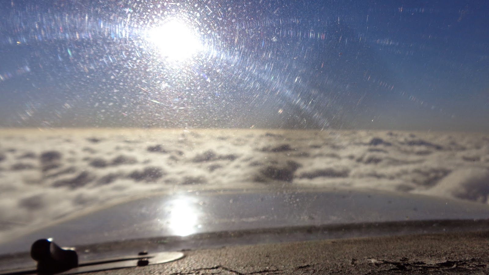
Chasing the sun West

When the weather did show signs of improvement I was lucky enough to be part of a long trip down to the top of the south island, flying the first and the third legs of a three flight day. The best part about the trip was that I was in the back seat when we crossed the Cooke Strait between the North and South islands, so was able to sit back and enjoy the views. Hopefully some of the pictures do it justice.

last time I race the Cessna's shadow whilst training

Luckily for me and my efforts to get home quicker I completed my final flight on Monday afternoon, and after Troy had offered to complete my sign out the next day I was in a position to change my flights. Annoyingly the earliest flight I could get was 48 hours later, but after rapidly completing the sign out and managing to join another cadet who was heading home on the Tuesday, I went to Auckland in the hope of finding some luck. Thankfully I was able to get a flight that evening getting me to Gatwick, and after ~30hrs of almost sleepless travel I made it home.

I've now got a couple of weeks off before my next phrase of training in Bournemouth, time I want to spend helping my sister as much as possible, getting to known my niece and catching up with Alice and my parents. It's not long before the most intimidating part of my training commences, so I plan to use the time off as much as possible. 

Sunday 10 August 2014

Week 46: Precision is everything

This week included work on the instrument landing system (ILS), an approach method that is considered as 'precision'. It is deemed as more precise as the pilot now has guidance in both azimuth (direction) and elevation (level), and is the principle instrument approach used at most commercial aerodromes. I was looking forward to this one the most as it is the type of approach I will fly for the majority of my career, so the simulator was positioned at Auckland to give it a go.

As previously mentioned the approaches we had worked through were known as 'non-precision'; effectively directional guidance is given to get you to the aerodrome itself, and the pilot must use the advisories on the plate to try and achieve the planned descent profile. These types of approaches can be flown very accurately, but the margin for error is a lot larger than with the ILS, and therefore additional safety factors are built in. The main one is the Minimum descent altitude (MDA); this level is indicated on the plate, and should be seen as the 'descent floor' for the procedure, below which the aircraft must not descend unless they are visual with the runway. The aircraft can fly level at the MDA in the hope of getting visual with the runway, but the longer this takes the steeper the final descent would have to be in order to complete the landing. In the case of Hamilton this is over 500 feet which puts the aircraft about a mile from the airfield, so when there is a combination of poor visibility and low cloud, the pilot is unlikely to complete the approach. 

In comparison the ILS has a 'decision altitude' (DA), a point where the pilot looks out the window to see if they are visual and can continue the approach. In the case of the ILS the aircraft can legally descend below this level, but if a missed approach is to be executed this will have been commenced as the aircraft passes the DA. This isn't as critical as the non-precision approach, as the aircraft would still be receiving track and level guidance, and as long as the aircraft wasn't dangerously low already it won't hit anything. This is prevented with the rule that if there is more than "half scale deflection" on the glideslope indicator, a missed approach must commence. 

This is the primary flight display from an Airbus instrument panel. In the centre is the artificial horizon (AH), the airspeed indicator is on the left (ASI), direction indicator at the bottom (DI), and the altimeter on the right. Between the AH and the altimeter there is a magenta diamond with four dots and a line. This is the glideslope indicator, the top and bottom dots being full scale deflection and the line being the centre. To fly the ideal approach the pilot will plan a rate of descent, then with minor adjustments they should be able to keep the diamond on the line, which will move to indicate what action is required from the pilot. In the case shown the diamond is indicating 'fly up', but this is due to the aircraft intercepting the glideslope from below so there is no issue. If however they get this indication once they had already intercepted the glideslope once, there would be a consideration that a missed approach must follow if the situation isn't rectified. 

For the moment these types of approaches are busy, but certainly manageable as the aircraft is easy to manipulate. When we get into the Airbus however the aircraft will have so much more inertia and is going considerably quicker, so accuracy is key to prevent any errors snowballing. Next up we've got more approaches and then we should be moving onto GPS routes in readiness for our last 5 flights in the Cessna. 

Sunday 3 August 2014

Week 45: Instrument flight

Flying this week has completely changed, from now on views out the window for 90% of the flight are purely for enjoyment rather than reference. The visual flight rules phrase for all intents and purposes has now finished (asides from a few upset recovery flights), further details flown with reference to the array of screens, dials, and instruments within the cockpit. Given this is the type of flying that will dominate our careers, the flights have almost taken on a different feeling, with a lot more procedural flying giving the perception of a more professional cockpit environment. That's not to say we were zooming about yelling yee-haa at the top of our lungs, but instrument flight inevitably leads to a very different mindset. 

Holding was the first port of call, initially looking at VOR (VHF Omnidirectional range) and NDB (Non-directional beacon) holds. These two things are ground based navigation facilities, sending out horizontal signals that aircraft can utilise to orientate themselves, as well as navigate from/to. They are also often used as a fix for holding, and as Hamilton has both types there are holds/approaches established over each, which were used during my simulator sessions. For those that care, an NDB is pretty much just a vertical aerial, and that's a VOR ----->

Given how intelligent modern aircraft are, holds tend to be flown with the autopilot engaged, the flight management computer continuously updating the aircraft's position in space so that the ideal hold can be flown with varying angles of bank. As good as the Garmin is, it's not that good so hold flying is as much about mental calculation as it is accurate flying. The calculations are focused on two areas:-
  1. Timing- the ideal scenario is that the wings level legs are flown to last 60 seconds in still air conditions, the corresponding distance giving the hold a fairly standard size. Nil wind is incredibly rare, so during the outbound leg if there is a headwind one additional second is added per knot of headwind, whereas with a tailwind one second is subtracted per knot. Therefore a comparison needs to be made between the aircraft's true airspeed and ground-speed, and how that affects the times, the resultant difference applied accordingly.
  2. Tracking- If there is a wind blowing across the hold, dependent on which side it's coming from one of the turns will be made a lot tighter and the other significantly wider. Without some sort of adjustment this is an unacceptable situation, as the aircraft will quickly leave the protected holding area and tracking back to the holding facility becomes increasingly more difficult. At CTC the double/triple drift technique is used, and as a result the outbound/inbound legs are not parallel but the hold is significantly more manageable. I've attempted to show the holds pictorially (sorry it's naf!); with a wind from the holding side the drift is tripled, and with the wind on the non-holding side the drift is doubled. This means that with the tighter/wider turns the new tracks help to achieve the correct inbound track. Both holds start at the cross, and go clockwise. 

Once the holds were meeting the right standards, procedural approaches were flown commencing from the hold facility. This involves flying away from the hold descending to a certain altitude, turning back onto a track towards the airfield, then descending at a certain rate of descent to achieve a procedure designed descent gradient, a gradient which ensure separation from obstacles on the approach. In some cases these approaches contain level advisories whereby the aircraft should be at a certain altitude at precise distances, but if the airfield has no facility for transmitting distance information the planned rate of decent needs to be flown as accurately as possible. These procedures create a much higher cockpit workload than with a visual approach, and to ensure a good approach is flown core skills of pre-planning, briefing and prioritisation are vital. The chart on the left (or plate) is for the VOR DME approach to runway 15 at Laos. The top section with a river running through the centre is a top down view which aids lateral planning, and the bottom section gives guidance for the vertical profile (The race-track hold can be seen to the right of the magenta text). There is a vast amount of information contained on the plate, a lot of which needs to be taken in prior to the approach being flown. This demonstrates how the workload quickly ramps up, as there are many criteria that must be met for the approach to be deemed safe. Plate not to be used for navigation.

Next up is GPS approaches, where imaginary points in space establish waypoints, but in essence the aircraft is flown as if there was something on the ground. The Garmin system is going to be of vital importance for this element, and without sounding like an idiot I am more scared of tuning the system than I am of flying the aircraft! We'll then move onto precision approaches using the instrument landing system, which ill talk about more next week.